

Day walks and overnight hikes in the Strzelecki Ranges, Gippsland

The Grand Strzelecki Track links Morwell and Tarra-Bulga National Parks through the forests of the Strzelecki Ranges in Gippsland. There are also three loops from Tarra-Bulga National Park that traverse Tarra Valley, Mount Tassie and Macks Creek. Choose from day walks and overnight hikes. Some sections are easy to medium, but overall it’s a Class 4 track (Australian Standards AS 2156.1 and AS 2156.2): narrow in places, with minimal facilities, so you’ll need to be self-sufficient and able to navigate. Please read the Track protocols before you go.
Check track conditions before you set out
Sections close for storm damage, harvesting and roadworks. See the latest track conditions on the homepage.
Choose your walk

Tarra Valley Loop
22.8 km · 1 day · ~8 hrs
Start and finish: Balook (loop)

Mount Tassie Loop
18.3 km · 1 day · ~6.5 hrs
Start and finish: Balook (loop)

Macks Creek Loop
25.1 km · 2 days · ~9 hrs
Start and finish: Balook (loop)
Diversion in place, see details below

Park to Park
26.9 km · 2 days · 11.5+ hrs
Start: Morwell National Park. Finish: inside Tarra-Bulga National Park, then 6.4 to 10.3 km to a road (car shuttle needed)
Currently closed (storm damage). Check current conditions

Tarra Valley Loop: day details
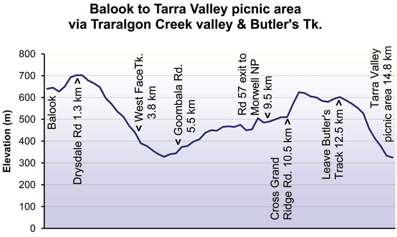
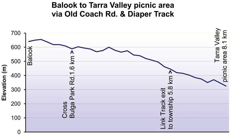
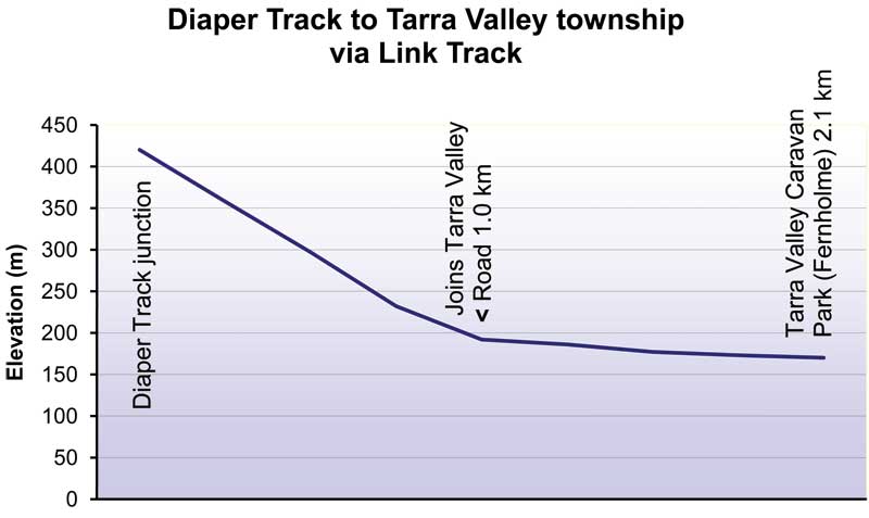
Balook to Balook, 22.8 km, about 8 hours. Walk it anticlockwise: via Drysdale Road, West Face Track, Goombala Road, Mountain Hickory Track, Duncan’s Track, Butlers Track and The Great Forest Walk down to Tarra Valley Picnic Area, then back up Diaper Track and Old Coach Road. Near the picnic area, the Rainforest Walk to Cyathea Falls is a must-do.
Elevation profiles
Mount Tassie Loop: day details
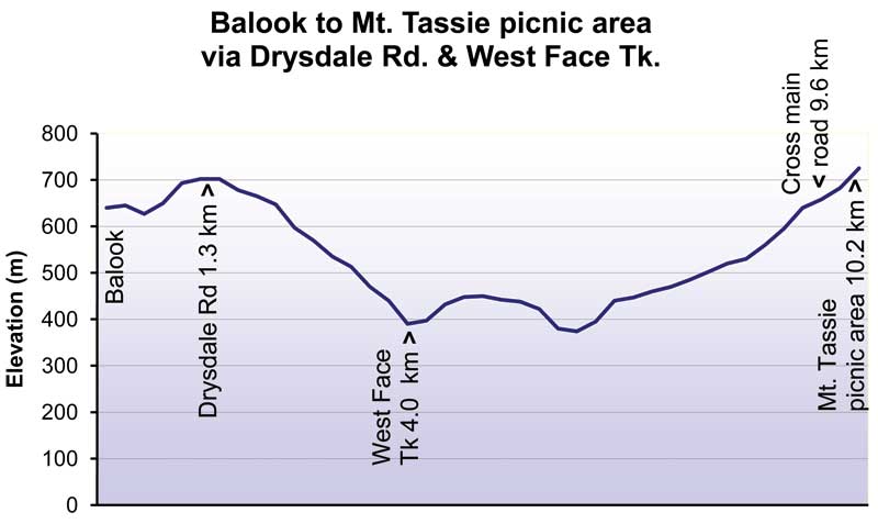
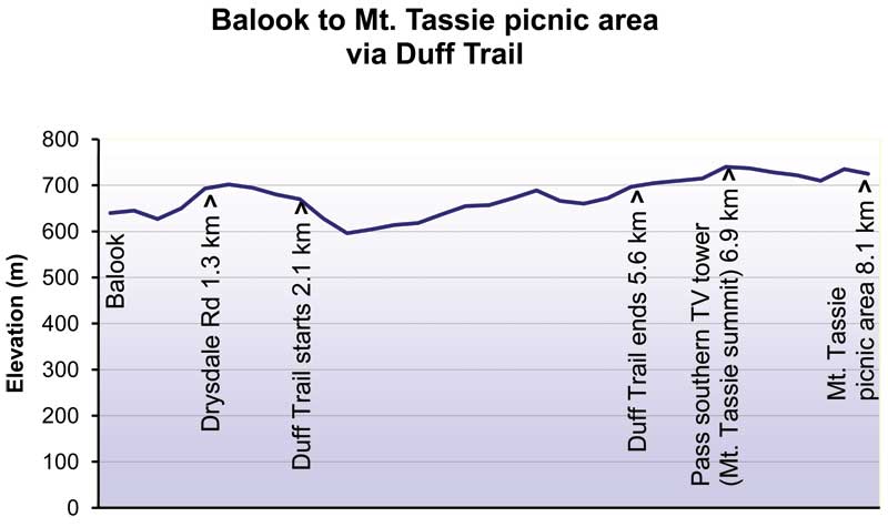
Balook to Balook, 18.3 km, about 6.5 hours. Walk it clockwise: via Link Track, Drysdale Road, West Face Track and Pine Trail Track to Mount Tassie, then back along the Duff Sawmill Heritage Trail.
Elevation profiles
Macks Creek Loop: day details and diversion
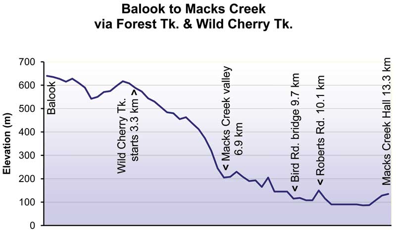
- Day 1: Balook to Macks Creek Hall, 13.3 km, about 5 hours
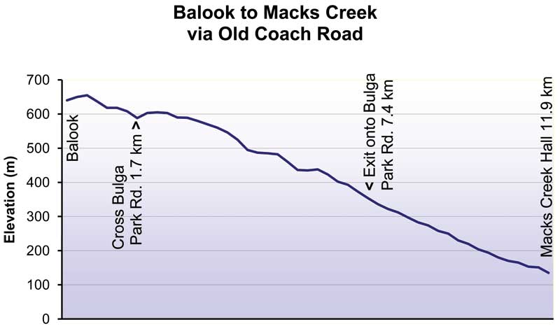
- Day 2: Macks Creek Hall to Balook, 11.8 km, about 4 hours
Current diversion on the Wild Cherry Track
The Wild Cherry Track has been diverted at the Tarra-Bulga National Park gate (shown in red on the map below). It moves about 200 metres away from Macks Creek, passing through some old plantation pines, then rejoins the Wild Cherry Track. You can hear the creek the whole way. Directional markers have been moved, and pink barrier tape and ribbons mark the route.

Elevation profiles
Park to Park: day details
- Day 1: Junction Road to Jumbuk Rest Area via Billys Creek, 13.1 km, 7+ hours
- Day 2: Jumbuk to the Mountain Hickory Track junction in Tarra-Bulga, 13.8 km, about 4.5 hours
One-way walk. Day 2 ends inside Tarra-Bulga National Park, with no road, so allow another 6.4 to 10.3 km to walk out to Pattison Rest Area, Balook or Tarra Valley. Arrange a car shuttle between the two parks.
Elevation profiles


Planning a multi-day hike? Read Vanessa’s 3 days and 76 km (2023) and Matthew’s multi-day walk (2021). More walkers’ stories are in Track Chat.
Before you go
Weather
Winters are cold, with occasional snow, and the area averages about 1,700 mm of rain a year. It gets roughly 1°C colder for every 100 m you climb. Check the Balook weather forecast before you leave.
Busiest time: summer (December to March). For quieter walks, try April to July. From our track counters.
What to pack
- Warm, waterproof clothing
- Insect repellent (ticks, leeches, march flies, mosquitoes)
- Toilet paper and a small trowel
- A bag to carry out all your rubbish
- Water treatment: water at rest areas isn’t drinkable
Where you can start
- Tarra-Bulga National Park Visitor Centre
- Tarra Valley Picnic Area
- Macks Creek Hall
- Morwell National Park, Junction Road
Where to stay and camp
Free rest areas
No booking needed: first come, first served. They are for walkers with swags or small tents only, with no access for campervans, caravans or motorhomes. Please treat water before drinking.
| Rest area | Facilities |
|---|---|
| Jumbuk (on Park to Park) | Toilet, shelter, picnic table, non-drinking water |
| Pattison (Balook) | Toilet, shelter, picnic table, non-drinking water |
| Morningside (Mount Tassie Loop) | Picnic table |
| Forget-me-not Falls (Mount Tassie Loop) | Picnic table |
| Macks Creek Hall car park | None |
| Bird Road Bridge (Macks Creek Loop) | None |
Camping near Tarra-Bulga National Park
No camping inside the national park boundaries or at the Tarra-Bulga National Park Visitor Centre (it does have public toilets and water).
To camp, use the free rest areas above or a paid campsite below, such as Tarra Valley Retreat Caravan Park.
Paid accommodation
Bookings are required for all paid campsites and cabins. Parking is available for guests.
Tarra Valley Retreat Caravan Park
Powered and unpowered tent sites and cabins in Tarra Valley, with camp kitchen, laundry, showers, toilets, drinking water and firewood.
Book ahead.
Phone +61 3 5188 0100 · tarravalleyretreat.com.au

The Barn at Glenwood Farm, Macks Creek
Accommodation for up to four guests on Roberts Road, near the Macks Creek Loop. Pets welcome.
Phone Julie 0438 952 602 or Steve 0428 825 900

Macks Creek Hall (groups)
Group room hire at $100 per night, with toilets, water and cooking facilities. You can also camp outside for free (no facilities).
If the hall is booked for a function, please camp at Bird Road Bridge Rest Area instead. Not sure? Phone Jenny first.
Phone Jenny +61 3 5186 1340 · mackscreekhall@gmail.com

Carrajung Estate (formerly Toms Cap Vineyard)
Dine-in, and dine-and-stay packages with wine tasting. Booking required.
Phone +61 3 5194 2215 · carrajung.com.au

More accommodation is available in Traralgon, Morwell, Churchill and Yarram, all within an hour of the track.
Getting there
The loop walks start from the Tarra-Bulga National Park Visitor Centre in Balook. Park to Park starts at the Junction Road car park in Morwell National Park, at Jeeralang Junction, about 5 km south of Churchill.
Locality map

Driving from Melbourne
- To Churchill (Park to Park start): about 2 hours east via the Princes Freeway. Watch for the Churchill and Federation University exit.
- To Balook (loop walks): about 2.5 hours via the Princes Highway. Take the Yarram / Loy Yang exit, turn right at the traffic lights just before Loy Yang Power Station, then follow the brown tourist signs to Tarra-Bulga National Park and Balook.
- Via Yarram: about 3.5 hours via the South Gippsland Highway, then follow the signs north through Tarra Valley to Balook.
- To Macks Creek Hall: 15 minutes north of Yarram (the last 2 km is gravel), then a further 12 km of gravel to Balook.
The Traralgon–Balook Road from Loy Yang and the Tarra Valley Road from Yarram are sealed. Other roads are gravel.
Driving from the Latrobe Valley
- To Park to Park (Junction Road car park, Morwell National Park): about 5 minutes from Churchill, 15 minutes from Morwell, 20 minutes from Traralgon and 25 minutes from Moe.
- To Balook (loop walks): about 35 minutes from Traralgon via the Traralgon–Balook Road, 40 minutes from Morwell or Churchill, and 50 minutes from Moe.
Drive times are approximate.
Public transport and car hire
- Train: V/Line to Morwell station, then the Latrobe Valley Bus Lines (Route 2) to Churchill.
- Coach: V/Line coaches run from Melbourne to Yarram (there is no train to Yarram).
- Bus: a service runs between Traralgon station and Yarram.
- Car hire: Budget, Hertz and Avis in Traralgon, or Turnbull’s Hire in Yarram (278 Commercial Road, phone (03) 5182 5722).
Parking
- Tarra-Bulga National Park Visitor Centre car park
- Morwell National Park car park, via Junction Road
- Goombala Road entry, directly opposite Pattison Rest Area at Balook
- Macks Creek Hall car park, Macks Creek
- Tarra Valley Picnic Area and Bird Road Bridge
No public parking at the Tarra Valley accommodation area unless you are staying there. RVs: limited parking at Yinnar (8 spaces, 48-hour limit).
Track rules
- No wood fires anywhere on the track, including at the free campsites. Use a fuel stove. Anyone seen or caught lighting a campfire will be reported and may face arson charges.
- No cats, dogs, horses, firearms or generators in Tarra-Bulga and Morwell National Parks (Parks Victoria policy).
- Flying a drone in the national parks needs a Parks Victoria permit.
For safety, campsite and minimal-impact guidance, read the Track protocols before you go.
Short walks from the Tarra-Bulga Visitor Centre
Only have a few hours? These walks start from the Visitor Centre car park at Balook. Distances and times are from Parks Victoria.
The Visitor Centre is run by Friends of Tarra-Bulga National Park volunteers and is open weekends and public holidays, 11 am to 4 pm (3 pm in winter). It closes on extreme-weather days.
| Walk | Distance | Time | What you’ll see |
|---|---|---|---|
| Fern Gully Nature Walk | 720 m | 15 min return | Rainforest walk |
| Corrigan Suspension Bridge | 1.2 km | 25 min one way | A must-do: the bridge runs through the rainforest canopy, with views of the fern gully below |
| Scenic Track | 1 km | 20 min one way | Links the bridge back to the car park |
| Lyrebird Ridge Track | 2.4 km | 45 min return | Combine with Forest Track for a loop through varied forest, with a low boardwalk over Macks Creek |
| Forest Track | 4.4 km | 1.5 hrs return | Varied forest, looping back to the Visitor Centre |
A short drive from Balook, the Duff Sawmill Heritage Trail is another easy walk: 3.7 km one way (about 1.5 hours) through Blackwood forest and old growth eucalypts, with signs telling the area’s sawmilling history. There’s parking at both ends.